Extension:ImageMap
|
|
ImageMap is an extension which allows clickable image maps. An image map is a list of coordinates in a specific image, which hyperlinks areas of the image to multiple destinations (in contrast to a normal image link, in which the entire area of the image links to a single destination). For example, a map of the world may have each country hyperlinked to further information about that country. The intention of an image map is to provide an easy way of linking various parts of an image without dividing the image into separate image files.
Syntax
The contents of an <imagemap> tag consists of blank lines, comments (starting with #) and logical lines. The first logical line specifies the image to be displayed. This must be in the same format as an ordinary MediaWiki image link, except without the enclosing [[ and ]].
Further lines are split into tokens, separated by whitespace. The function of each line is determined by the first token in the line. All coordinates are according to the full-size image, not the visible image. They should be specified as (distance from left edge, distance from top).
- desc
- Specifies the location of the image description link. May be either top-right, bottom-right, bottom-left, top-left or none. This puts a blue "i" icon in the specified corner, linking to the image description page. The default is bottom-right. To hide the description link, set it to none. Possible values: top-right, bottom-right, bottom-left, top-left, none
- poly
- A polygon. The coordinates of the vertices are given, followed by a link in square brackets.
Polygons must be defined before any other form!
- rect
- A rectangle. The parameters are the coordinates of the top-left and bottom-right corners, followed by a title to link to in square brackets.
- circle
- A circle. The first two parameters are the coordinates of the center, the third is the radius. The coordinates are followed by a link in square brackets.
- default
- This gives the default link, where no other regions are specified.
All coordinates are specified relative to the source image. The image can be scaled using thumbnail syntax, in which case the image map coordinates will be automatically scaled as well.
All links are given in either the form [[Page title]] or [[Page title|description]]. In the latter case, the part after the pipe "|" becomes the title attribute of the link -- in most browsers, it will pop up as a tooltip when the user hovers over it. If no explicit link description is given, the page title will be used.
Areas which overlap give precedence to the first link listed.
Example
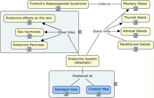
Code
<imagemap>
Image:WikiPath Endocrine Content Map.jpg|WikiPath Endocrine Content Map
rect 507 180 525 198 [[:Category:Parathyroid Glands - Pathology]]
rect 103 130 121 148 [[Reproductive Hormones Overview - Anatomy & Physiology]]
rect 507 127 525 145 [[:Category:Adrenal Glands - Pathology]]
rect 103 77 121 95 [[Endocrine effects on the skin - Pathology]]
rect 212 24 230 42 [[Frohlich's Adiposogenital Syndrome]]
rect 243 351 261 369 [[:Category:Endocrine System - Pathology]]
rect 507 24 525 42 [[:Category:Pituitary Gland - Pathology]]
rect 507 77 525 95 [[:Category:Thyroid Gland - Pathology]]
rect 102 180 120 198 [[Endocrine Pancreas - Pathology]]
rect 366 352 384 370 [[Endocrine System (Content Map) - Pathology]]
desc bottom-left
<nowiki></imagemap>
Output